Cassini successfully completed a flyby of Titan on April 10, 2007. The spacecraft flew over new parts of familiar terrain on the Saturnian moon-its north polar region. In images from this radar pass, more lakes or seas are expected to be visible.
Among the new parts of familiar terrain imaged was the other side boundary of the 'black sea,' which could tell scientists more about its size. Additionally, the radar team aligned this pass slightly southward so that it will line up with a future altimetry flyby planned for May 12.
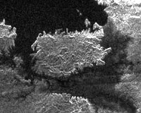
This radar image, obtained by Cassini's radar instrument during a near-polar flyby on Feb. 22, 2007, shows a big island smack in the middle of one of the larger lakes imaged on Saturn's moon Titan. This image offers further evidence that the largest lakes are at the highest latitudes.
The island is about 90 kilometers (62 miles) by 150 kilometers (93 miles) across, about the size of Kodiak Island in Alaska or the Big Island of Hawaii. The island may actually be a peninsula connected by a bridge to a larger stretch of land. As you go farther down the image, several very small lakes begin to appear, which may be controlled by local topography.
This image was taken in synthetic aperture mode at 700 meter (2,300 feet) resolution. North is toward the left. The image is centered at about 79 north degrees north and 310 degrees west.
