The devastating fires in southeastern Australia have renewed focus on the dangers that extreme drought and heat can pose to society. Last week, fires erupted near populated areas in Victoria and New South Wales with destructive effects, resulting in one of Australia's largest evacuations. NASA's CALIPSO satellite provided data for a new animation that showed the aerosols generated from the smoke has spread high into the atmosphere and far to the east over the Pacific Ocean.
The intense heat from the bush and forest fires initiated unusual convective storms known as pyrocumulonimbus storms (pyroCbs).
"Large and numerous pyrocumulonimbus events are relatively rare – especially at this scale," said Chip Trepte, CALIPSO's Project Scientist at NASA Langley Research Center in Hampton, Va.
These storms are fueled by both heat from the fires and water vapor in the atmosphere, which allow them to grow into thunderstorms. Strong winds from these storms can fan fires into raging infernos. There have been more than 20 firestorms just in the past week. And Mike Fromm and colleagues from the Naval Research Laboratory, Washington, are still counting.
"By our measures, this is the most extreme pyrocumulonimbus storm outbreak in Australia," Fromm said.
A significant firestorm that previously occurred in Australia on February 7, 2009 is known as "Black Saturday" because of the unprecedented destruction and loss of life. Beyond Australia, pyrocumulonimbus are also common in the forests of the western U.S., across Canada and Siberia. Pyrocumulonimbus have also been observed in Portugal, Bolivia, Argentina and South Africa. In these cases, large amounts of smoke particles were lofted into the atmosphere through the pyrocumulonimbus and can be transported long distances by upper atmospheric winds.
Over the past week, NASA satellites have observed an extraordinary amount of smoke injected into the atmosphere from the Australian fires and its subsequent eastward dispersal. Observations from NASA's Cloud-Aerosol Lidar and Infrared Pathfinder Satellite Observations (CALIPSO) satellite shows smoke plumes reaching 11 miles (17.7 km) vertically into the lower stratosphere from some energetic firestorms.
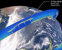
The animation shows RGB color images from NASA's Moderate Resolution Imaging Spectroradiometer (MODIS) instrument on NASA's Aqua satellite for December 31, 2019 through January 5, 2020. A plume of brown smoke extends from the southeastern coast of Australia, over the Tasman Sea and beyond into the Pacific Ocean.
The overlaid vertical cross sections show CALIPSO lidar observations for these same days. The bright colors indicate the presence of small particles (aerosols) and the white color indicates clouds.
Visible in each of the cross sections near 40 degrees south is a thick layer of smoke from the fires at altitudes above 9 miles (14.5 km). The dark shading below these layers is due to the absence of lidar signals below the opaque smoke layers. These layers contain very small particles and have optical properties similar to smoke.
The sequence of CALIPSO and MODIS tracks in the animation indicates the continued transport of the smoke layer to the east. As of Jan. 5, 2020, smoke was detected more than 4,000 miles from the source.
"We anticipate that the plume will continue its movement over the next days, and the CALIPSO team will continue to monitor its progression," said Trepte.
