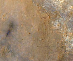
An image from NASA's Mars Reconnaissance Orbiter shows NASA's Curiosity Mars rover and the wheel tracks from its landing site to the "Glenelg" area where the rover worked for the first half of 2013.
The orbiter's High Resolution Imaging Science Experiment (HiRISE) camera captured the scene on June 27, 2013, with the orbiter rolled for an eastward-looking angle rather than straight downward. The afternoon sun illuminated the scene from the western sky, so the lighting was nearly behind the camera.
This geometry hides shadows and reveals subtle color variations.
Curiosity that day was examining an outcrop called "Shaler," the rover mission's final science target in the Glenelg area before commencing a many-month trek southwestward to an entry point for the lower layers of Mount Sharp.
The rover appears as a bright blue spot in the enhanced coloring of the image.
The image shows two scour marks at the Bradbury Landing site where the Mars Science Laboratory mission's skycrane landing system placed Curiosity onto the ground on Aug. 6, 2012, EDT and Universal Time (Aug. 5, PDT).
The scour marks are where the landing system's rockets cleared away reddish surface dust. Visible tracks commencing at the landing site show the path the rover traveled eastward to Glenelg.
