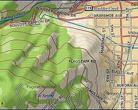
DeLorme has announced its release of the 2009 edition of USA Topographic Map Data for use with the XMap GIS software suite. This unique dataset offers users of DeLorme's three-tiered XMap GIS suite a highly detailed and customizable base map with coverage for the U.S., Canada, and Mexico on a single DVD.
This latest release of the USA Topographic Map Data 2009 includes a significant number of updates and other improvements including:
+ Over 30,000 new or updated roads and streets in the U.S.
+ Detailed road and street coverage for Canada and major roads in Mexico
+ 200,000 new places-of-interest
+ More than 4,000 new trails
+ Enhanced map colors for superior cartographic display
+ Improved horizontal accuracy
Because USA Topographic Map Data 2009 is in vector format, map features can be turned on or off as needed providing an optimized backdrop for managing and displaying your GIS layers or other map data. Unlike raster-based topographic maps, USA Topographic Map Data 2009 is scalable so the optimal concentration of map features is displayed at every zoom level.
As an integrated component of the XMap suite, the USA Topographic Map Data 2009 adds value to the software by enabling key features and functions:
+ 3-D Terrain modeling
+ Elevation profiling
+ Customizable contour and shaded relief display
+ Road and trail routing as well as in-vehicle navigation
+ Address geocoding
With over 30 years experience developing and managing spatial datasets for use in a broad range of mapping products, DeLorme has earned a well-deserved reputation for the quality of its map data. The USA Topographic Map Data 2009 offers XMap users the foremost North America map dataset available.
Share This Article With Planet Earth
