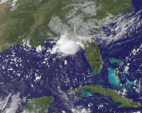
Tropical Storm Claudette hit Florida early Monday, lashing tourist resorts with strong winds and heavy rain as the first Atlantic hurricane of the season gathered power.
Claudette wreaked havoc in Florida resorts as Tropical Storm Bill was reclassed as a hurricane by the US National Hurricane Center (NHC) in Miami.
Emergency response teams were activated in the Florida Panhandle as the region braced for possible flooding.
"The main threat from Tropical Storm Claudette is heavy downpours and isolated tornadoes today and tonight in the Florida Panhandle and Big Bend counties," the Florida Division of Emergency Management warned in a statement.
Up to 10 inches (25 centimetres) of rain was expected to fall in some parts because of the storm.
Residents kept inside in the face of choppy seas and pouring rain, but there was no massive stocking up of food or other emergency supplies, according to local media reports.
The Hurricane Center said Claudette — the first storm to make landfall this year — packed sustained winds of 40 miles (65 kilometers) and moved inland at the Florida-Alabama border at about 12 miles (19 km) per hour.
The storm hit land near Santa Rosa island, just southeast of Fort Walton Beach just after midnight, the Hurricane Center said. But it was "expected to weaken to a tropical depression later this morning," the center predicted.
Claudette appeared suddenly on Sunday in the Gulf of Mexico, while most Atlantic hurricanes usually begin far from the US coast.
Hurricane Bill remained far from land but was building in intensity.
At 0900 GMT, the new hurricane was churning in the middle of the Atlantic, 1,160 miles (1,870 kilometers) east of the Lesser Antilles, according to the NHC.
The storm was moving northwest at 22 miles (35 km) an hour, packing sustained winds of 75 miles (120 km) an hour, the center said.
Bill was expected to continue in this general direction for one or two days. "Strengthening is forecast during the next day or two," the advisory said. "And Bill could become a major hurricane by Wednesday."
Meanwhile, Ana, which formed as a tropical storm early Saturday, weakened to a tropical depression and crept toward Hispaniola, prompting storm watches in the area.
However, its punch was expected to weaken, with US forecasters saying "Ana could degenerate into a tropical wave on Monday."
The trio had formed the season's first three named storm systems in the Atlantic.
In the Pacific, Hurricane Guillermo weakened, too. It crossed into the Central Pacific, with its center located more than 995 miles (1,600 km) east of Hawaii, moving northwest at about 14 mph (22 kmh), the NHC said.
With winds having decreased to near 85 mph (140 kmh), it was forecast to weaken to a tropical storm later Monday.
A tropical storm, which has winds of at least 39 mph (63 kmh), becomes a hurricane when its winds reach at least 74 mph (119 kmh).
The Atlantic hurricane season began on June 1 and continues through November 30.
Share This Article With Planet Earth
