Rising temperatures should trigger a global "red alert", the United Nations' weather and climate agency chief said Wednesday, after global heat indices again smashed records in August.
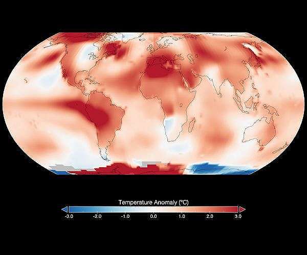
The world saw record average temperatures in August for the second year running, preliminary data from the EU's climate monitor seen by AFP showed.
And Australia, Japan, parts of China and Norway all experienced their hottest August on record, according to meteorological agencies.
"It's clear that the temperatures are rising… above what we would like," said Celeste Saulo, head of the World Meteorological Organization (WMO).
"And it is because the action is not enough."
While the exact average global temperature for August 2024 is not yet known, the EU's Copernicus Climate Change Service (C3S) has established it will be above the record 16.82 degrees Celsius (62.28 Fahrenheit) measured in August last year.
"Thresholds are all the time being beaten," Saulo said, speaking in Singapore at a regional climate forum of local meteorological services.
Saulo also called for better monitoring and support for meteorological agencies, adding that "we need more resources".
The forum comes days after the WMO released its latest assessment on the impacts of climate change in Asia and the Pacific, warning that sea-level rise is above average in many areas.
And the record August continues a near-unbroken 15-month streak, where each month eclipsed its own temperature record for the time of year, according to the C3S.
The climate forum also announced the designation of Singapore as a regional hub for monitoring pollution caused by vegetation fire and smoke.
One of only two such centres in the world, the facility will offer better quality information on fires and pollution forecasts, plugging a gap in regional data, officials said.
California girds for punishing heatwave
Los Angeles, United States (AFP) Sept 3, 2024 –
Californians were being warned Tuesday to prepare to swelter as a fearsome heatwave settles over the western US state.
The mercury was forecast to top out at a scorching 113 Fahrenheit (45 Celsius) in parts of Los Angeles later in the week, marking the high point of an already hot summer.
Meteorologists say a ridge of high pressure could push temperatures 20 degrees higher than usual for this time of year in some places, with dangerous conditions expected for several days.
The National Weather Service said an excessive heat warning would be in place from lunchtime on Wednesday until after sunset on Friday.
The Woodland Hills area of Los Angeles, a well-to-do neighborhood northwest of downtown, was expected to be the hottest part of LA County.
Los Angeles Mayor Karen Bass ordered the opening of cooling centers throughout the city where people who may not have access to air conditioning will be able to take shelter.
Although not quite as high, the soaring temperatures will also affect coastal areas, which usually escape the worst of the heat and have enjoyed a relatively balmy August.
Climate scientist Daniel Swain said the next few days will be a taste of what inland areas of the state have already endured.
"Most of California's immediate coastline missed out on record heat this season (including some of the most densely populated portions of the SoCal megalopolis)," he wrote on his Weather West blog.
That means "that while a majority of California's land area did indeed just experience a record-hot summer, the majority of California's population likely did not."
Death Valley — routinely one of the hottest places on Earth — is likely to see the mercury hit 118 Fahrenheit, though that is slightly lower than the almost 122 F it saw in July.
Further inland, the heat will also affect parts of Arizona, including Phoenix, where Tuesday marked the 100th day in a row that the temperature had topped 100 Fahrenheit.
And there was no respite in sight for the state's biggest city, with blistering heat expected throughout the week.
High temperatures in the southwestern US — much of which is desert — are not unusual at this time of year.
But scientists say human-caused global warming is pushing norms higher, and creating more unstable weather patterns.
World sees record August heat for second year running
Paris (AFP) Sept 3, 2024 –
The world saw record average temperatures in August for the second year running, according to preliminary data from the EU's climate monitor seen by AFP on Tuesday.
While the exact average temperature for August 2024 is not yet known, the Copernicus Climate Change Service (C3S) has already established it will be above the then-record 16.82 degrees Celsius (62.28 Fahrenheit) measured in August last year.
Scientists warn that these unprecedented temperatures are in large part driven by man-made climate change, which is causing more frequent and intense extreme weather events.
Australia, Japan, several Chinese provinces and Norway's Svalbard Arctic archipelago all experienced their hottest August on record, according to various meteorological agencies.
It continues a near-unbroken 15-month streak where each month eclipsed its own temperature record for the time of year, according to the C3S.
Only July 2024 was measured by C3S to be slightly cooler than July 2023, though the US NOAA weather agency believes July 2024 to be the hottest month on record.
Either way, 2023 was the world's warmest year since weather data keeping began in the 19th century, according to the various climate monitors.
And at the beginning of August, C3S had already warned that it was "increasingly likely" 2024 would surpass it.
It said that July 2024 was 1.48 C (34.66 F) warmer than the estimated average temperatures for the month during the period 1850-1900, before the world started to rapidly burn fossil fuels — the biggest contributor to climate change.
Climate researchers dedicated to studying the weather in the period before the advent of meteorological instruments believe the current high temperatures to be unseen in at least 120,000 years.
