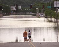
Near record spring floods could begin to swamp large parts of the US midwest as early as next week, the National Weather Service warned Thursday.
The Red River valley — the scene of devastating floods in 1997 — has experienced above average snowfall over the winter and the heavy runoff onto still-frozen ground poses "an imminent serious flood threat," the weather service said.
"We are looking at a situation with all the ingredients for near record flooding in the upper Midwest," said Jack Hayes, director of the National Weather Service.
"Sudden snowpack melts due to warm temperatures or a heavy rain could further complicate the flooding on the northern plains."
Forecasters expect flooding to begin next week and warned that the Red River in North Dakota could see a crest among the top five highest on record.
Widespread over-land flooding is expected due to the flat terrain and frozen drainage networks in the Red River Basin.
The threat is so great that the weather service created a new category — high risk — to distinguish it from the existing 'above average' category for flood potential.
Officials in North Dakota and neighboring Minnesota have already begun preparations for the floods.
Recent flooding in Illinois and Ohio due to heavy rain has begun to recede, but the weather service said the saturated ground is could flood again should it rain.
The weather service's spring outlook also warned of a worsening drought in Florida but said much-needed rain has helped relieve intense drought conditions in Texas, Oklahoma and California.
