Zoombak has announced that it has added state-of-the-art online mapping technology to its interactive Web site through the integration of Microsoft Virtual Earth.
The new online mapping platform provides Zoombak users with a variety of enhanced viewing options and features. In addition to allowing customers to quickly pan and zoom the standard map, they can now visualize the location of their Zoombak A-GPS locator with street-level and aerial views.
The enhanced mapping functionality is available immediately to all Zoombak customers and does not require existing customers to upgrade their hardware or service agreements.
"By integrating Microsoft's Virtual Earth online mapping technology with the most accurate A-GPS locator consumers can buy, Zoombak delivers even greater peace of mind," said Simon Buckingham, chief executive officer of Zoombak.
"Thanks to new advanced mapping capabilities, customers have powerful new tools that can help them visualize the location of their most valued possessions."
Zoombak provides consumers with the ability to stay connected to the things that matter most. Using Zoombak's interactive Web site and newly enhanced mapping capabilities, customers can set up custom safety zones around virtually any location including homes, parks, malls and schools.
When the device crosses one of the virtual boundaries, a text message or e-mail alert promptly notifies customers of the location of the device. Customers can also pinpoint their Zoombak's location at any time on-demand from both their mobile phone and zoombak.com.
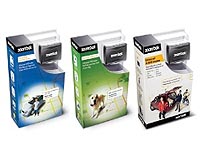
Starting at an affordable price of $199 plus a low cost monthly service plan, Zoombak is the only A-GPS locator already available nationwide at leading consumer electronics, specialty pet and automotive retailers including Pep Boys, PetSmart, Al and Ed's Autosound, CircuitCity.com and BestBuy.com.
