Are you wondering what the total solar eclipse in late summer will look like from your patio? Or where to travel to get the best view of the eclipse?
You can enter the ZIP code or name of your city or town and see an animation of how the Sun will move across the sky over a three-hour period – sped up 1,000 or 4,000 times – and how much of a bite will be taken out of the Sun by the eclipsing Moon.
If you are lucky enough to be inside the path of totality, the simulator shows the eerily darkening sky that eclipse fanatics travel around the world to experience.
"There are lots of online animations of the 2017 eclipse, but you can't use them like ours to get a sense of the full experience, including your surroundings," said Dan Zevin, who is with the Multiverse education team that is leading the project at UC Berkeley's Space Sciences Laboratory. "Our simulation is closer to what one might experience in a planetarium show."
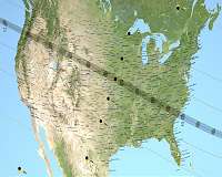
A simple click will reveal a map of where you live relative to the path of totality, which will stretch across 12 states in a band at most 72 miles wide.
For the full "total solar eclipse" experience, getting within the path of totality is key.
"If you are off to the side – even just a little bit where the Sun is not 100 percent covered by the Moon – it is like being in the parking lot of the stadium during the Super Bowl but not really inside seeing the game," said Jay Pasachoff, the Field Memorial Professor of Astronomy at Williams College and the Megamovie team's expert eclipse adviser.
NASA Satellites Ready When Stars and Planets Align
The movements of the stars and the planets have almost no impact on life on Earth, but a few times per year, the alignment of celestial bodies has a visible effect. One of these geometric events – the spring equinox – is just around the corner, and another major alignment – a total solar eclipse – will be visible across America on Aug. 21, with a fleet of NASA satellites viewing it from space an … read more